


Stevenson 2

Chabard
User

Length
25 km

Max alt
1215 m

Uphill gradient
806 m
Km-Effort
34 km

Min alt
761 m

Downhill gradient
536 m
Boucle
No
Creation date :
2025-06-27 06:38:30.0
Updated on :
2025-06-27 15:24:49.595
8h44
Difficulty : Very difficult

FREE GPS app for hiking
 SityTrail
IGN / Geographical institutes
SityTrail Plus
The world is yours!
About
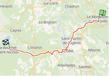
Trail Walking of 25 km to be discovered at Auvergne-Rhône-Alpes, Haute-Loire, Le Monastier-sur-Gazeille. This trail is proposed by Chabard.
Description
Monestier - Bouchet saint Nicolas
Positioning
Country:
France
Region :
Auvergne-Rhône-Alpes
Department/Province :
Haute-Loire
Municipality :
Le Monastier-sur-Gazeille
Location:
Unknown
Start:(Dec)
Start:(UTM)
578559 ; 4976592 (31T) N.
Comments